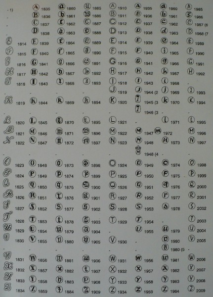
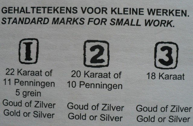
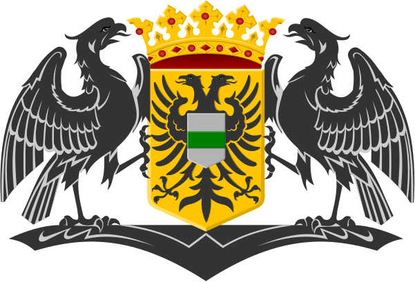
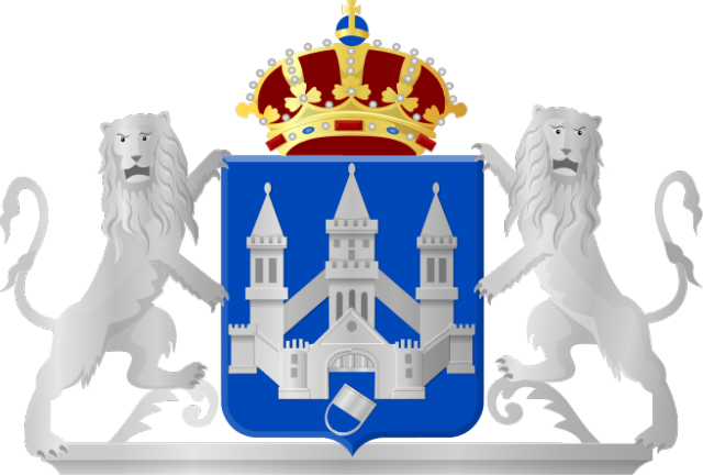
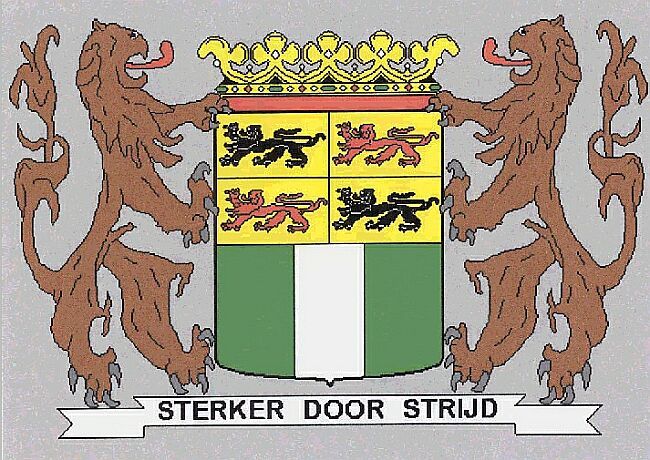
 City of Medemblik
Medemblik was an important trading town off the Zuider Zee, today’s IJsselmeer. Count Floris V built a huge fortified castle in order to keep the people under control. Today it is known as Radboud Castle and visitors can tour the building.
Medemblik was a prosperous trading town, when in 1282, Floris V, Count of Holland, successfully invaded West Friesland. He built several fortresses to control the region, one of which was Kasteel Radboud in Medemblik, and awarded Medemblik city rights in 1289. After Floris V had been murdered in 1296, the local Frisian besieged the castle, but in 1297 an army from Holland thwarted their efforts to starve out the inhabitants, which included Medemblik citizens.
Several more attacks took place in the following centuries. The most notorious of these happened in June 1517, when Medemblik was attacked from mainland Frisia by about 4000 pirates known as the Arumer Zwarte Hoop, led by Pier Gerlofs Donia and Wijard Jelckama. Many citizens fled to the castle, which the pirates unsuccessfully besieged. Eventually, they took out their fury on the town, which burned to the ground. After this, the band continued their marauding path on land throughout present day province of North Holland.
Medemblik obtained town walls in 1572, so that the castle lost its roll as a refuge for the citizens, which led to its partially dismantling in 1578. Over the centuries the castle fell into decay, but in 1889 it became property of the crown and was restored to be used as a courthouse, which function it served until 1934. Anticipating the German invasion, the Rijksmuseum in September 1939 chose the castle as the initial hiding place of Rembrandt's Night Watch.
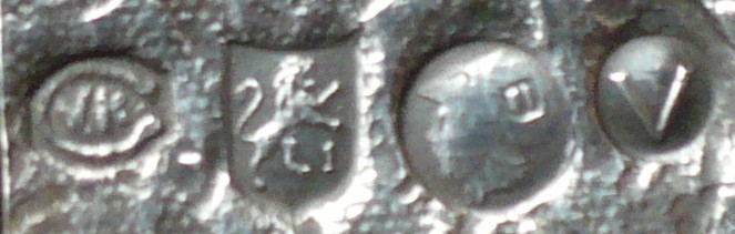
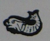
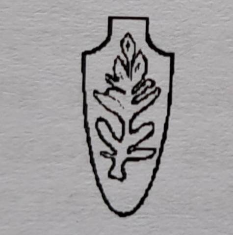
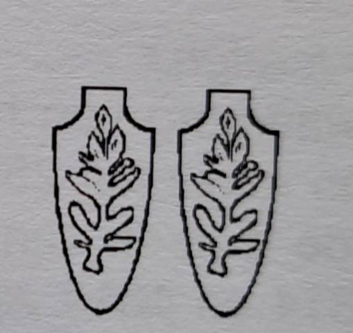
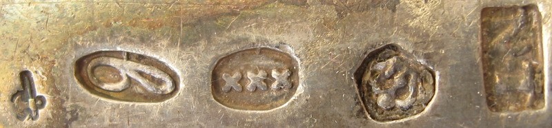
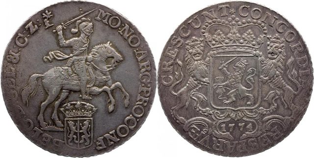
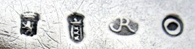
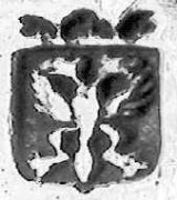
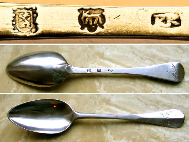
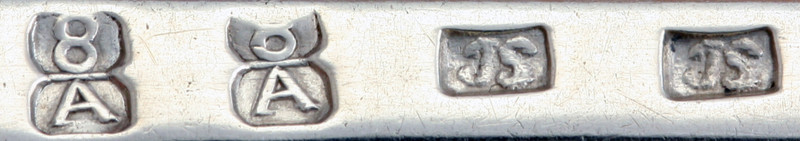
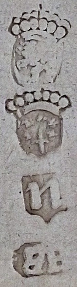
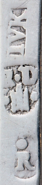
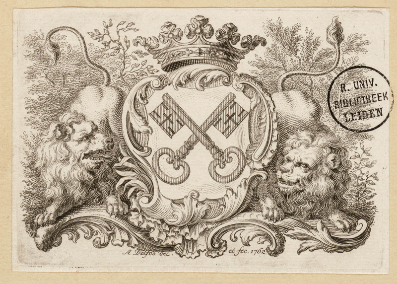
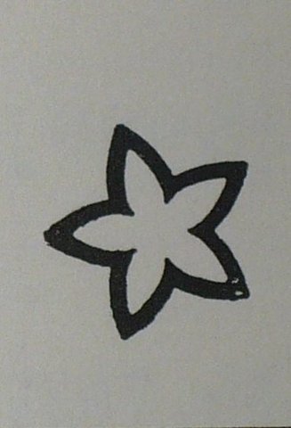
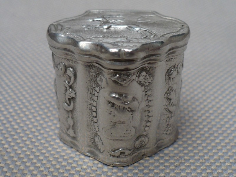
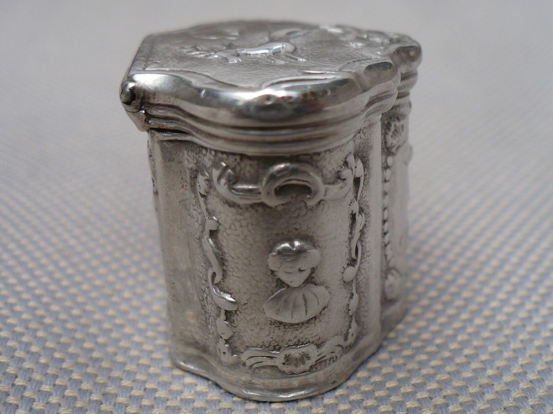
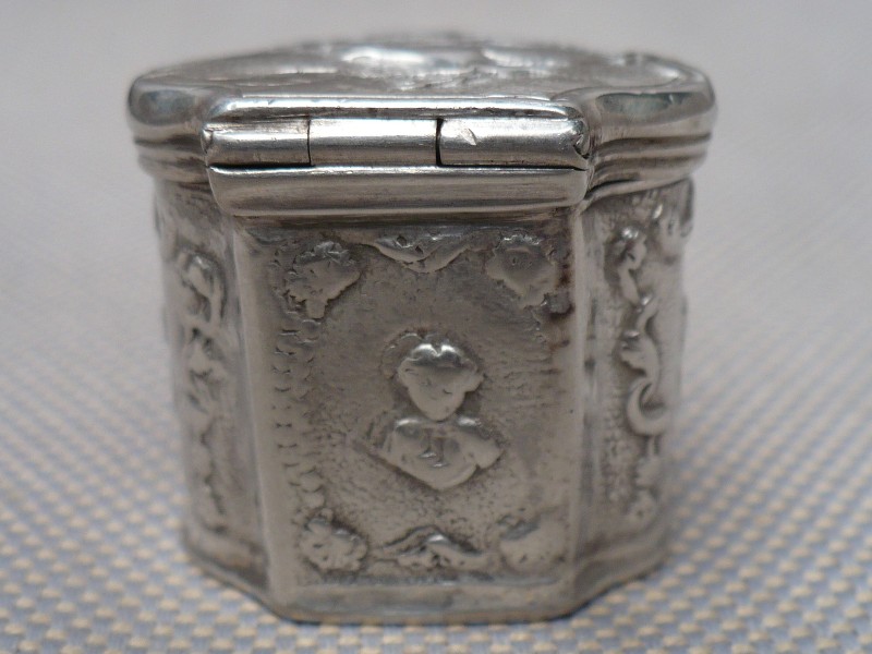
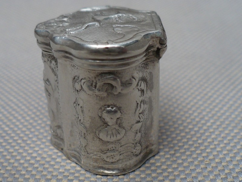
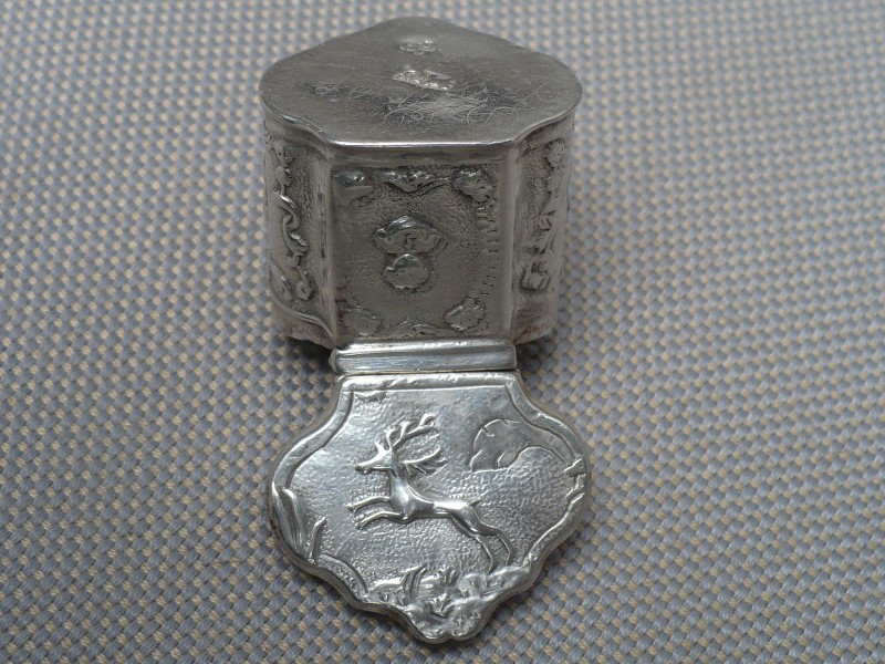
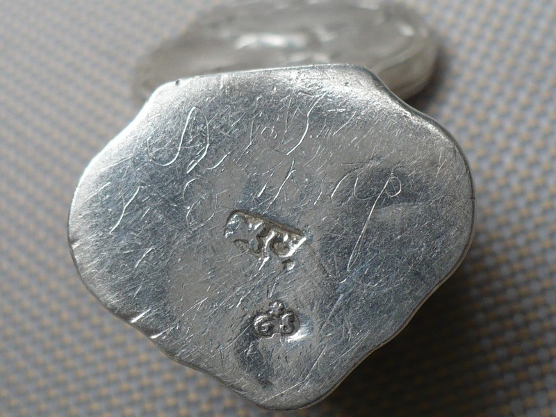
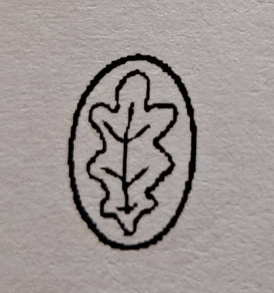
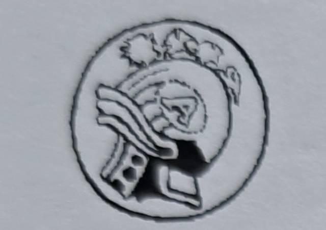
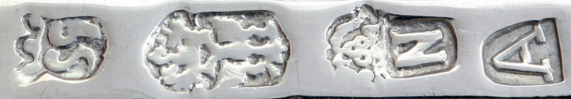
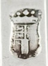
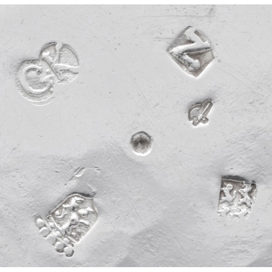
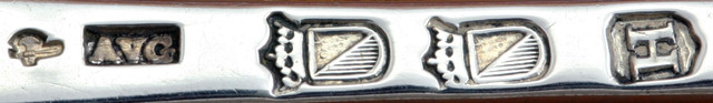
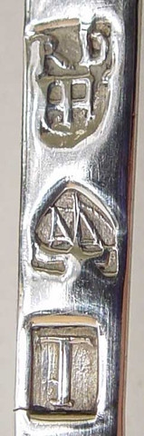
The silver guild of Medemblik was founded in 1785

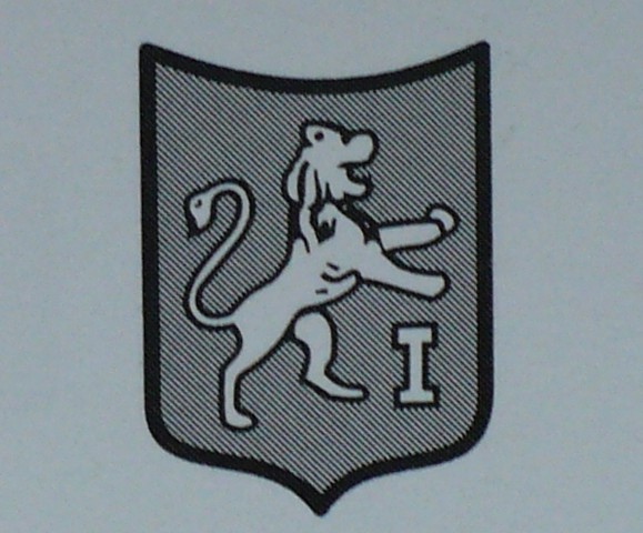
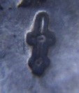
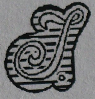
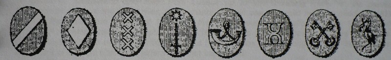
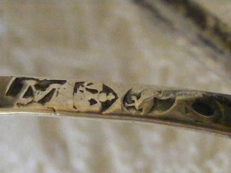
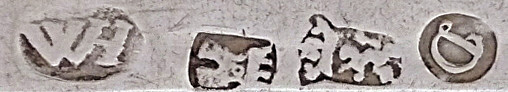
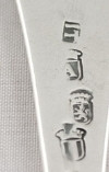
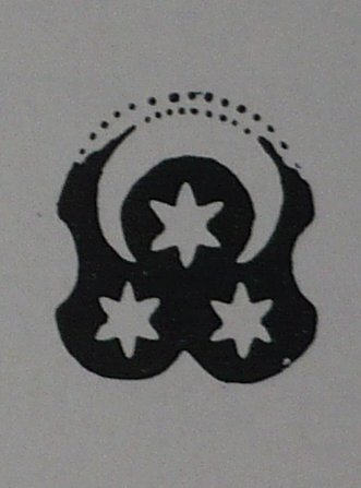
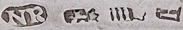
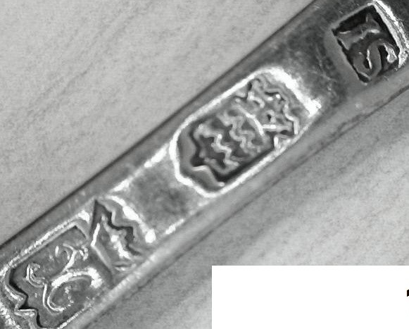
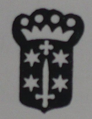
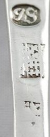
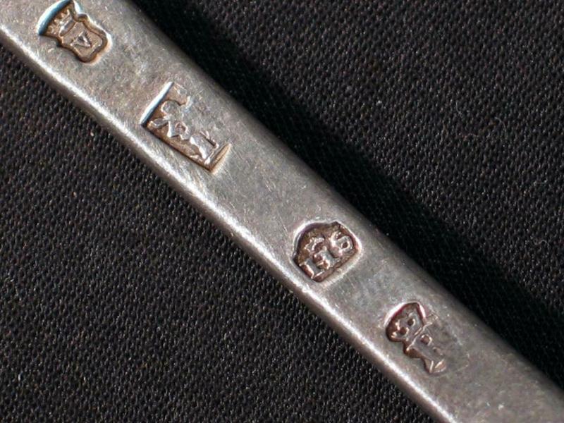
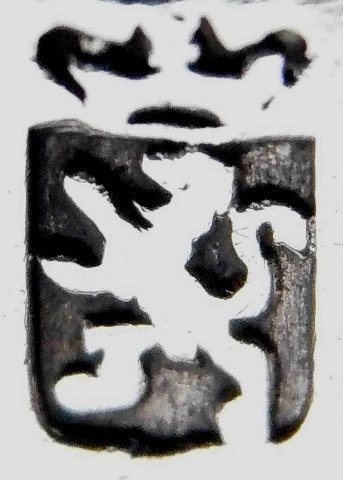
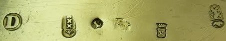
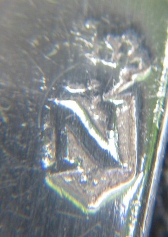
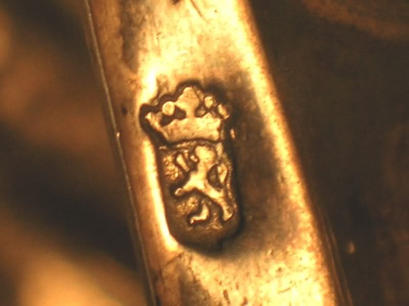
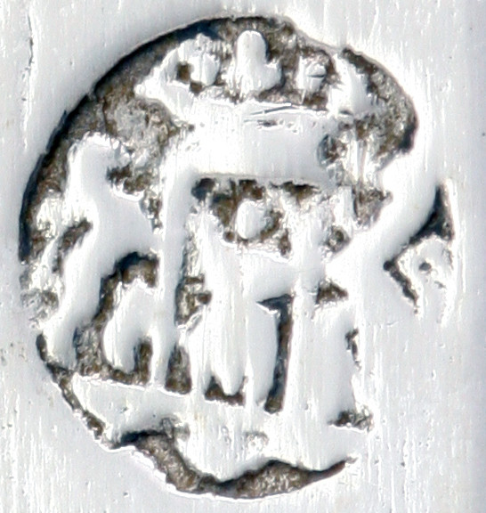
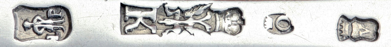
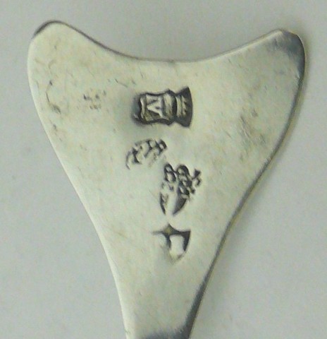
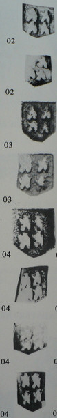
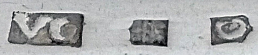
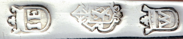
Town mark of Medemblik (the small beam idicating water/canal), maker's mark WL for:Willem Lippits, born 1766-1813(died), year letter G(?) for 1791
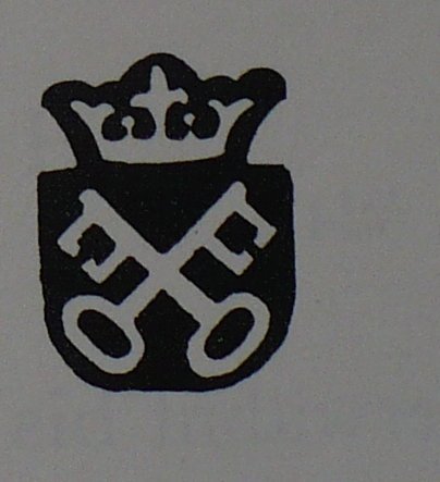
City mark of Meppel.
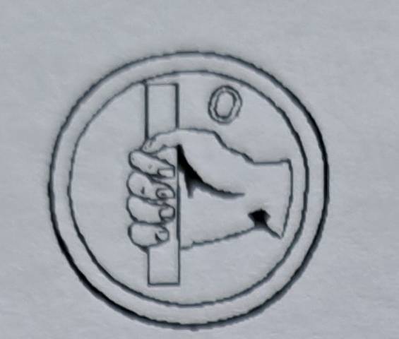
. Meppel is a municipality and a city in the northeast of the Netherlands, in the south-west of the province Drenthe. It developed in the 16th century as a transport and distribution inland harbour for turf. There used to be a lot of waterways in the town, but now only one remains. People born in Meppel are occasionally referred to as 'Meppeler Muggen'; this translates as mosquitos/gnats from Meppel. This is due to a traditional folk tale. The people of Meppel thought the church tower was on fire. After closer inspection it was only a swarm of mosquitos.
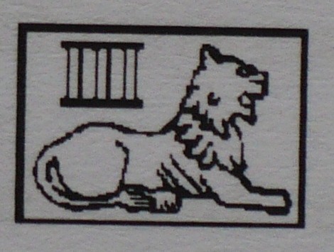
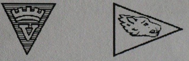
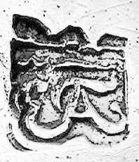
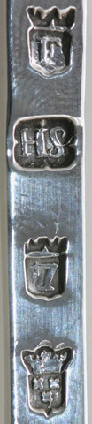
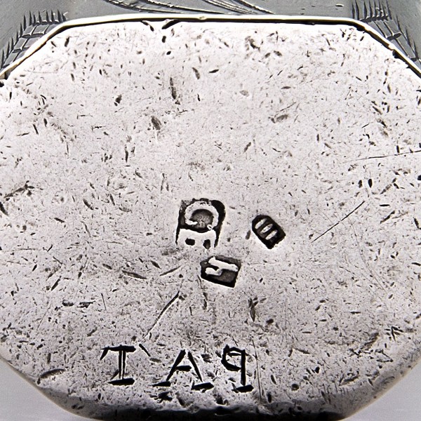
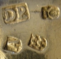
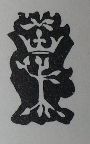
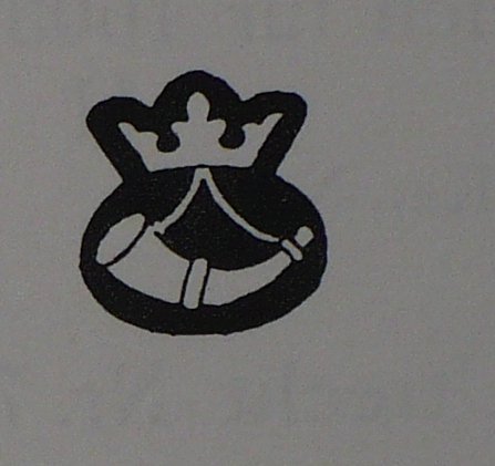
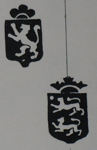
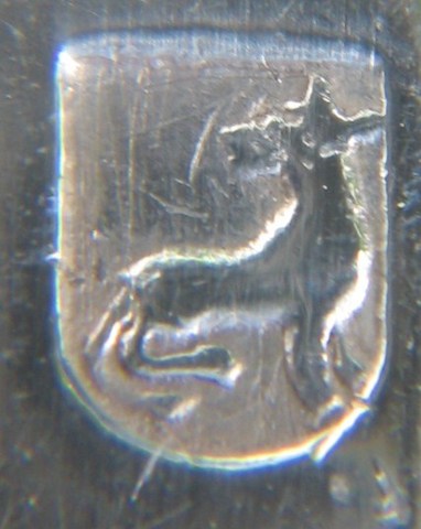
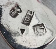
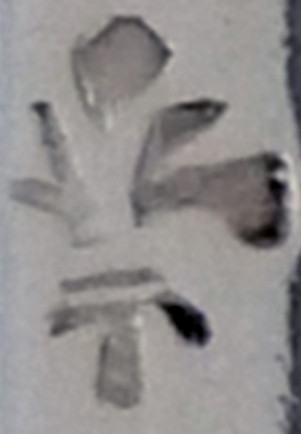
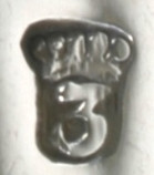
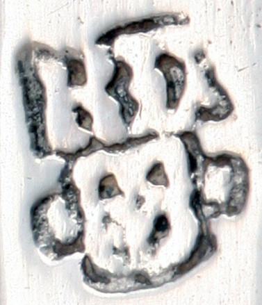
The town mark on Meppel silver has derived from the lordshipseal ("landschapszegel") of Drenthe. This seal originated in the monastery of Maria in Campis. The Asser Coat of Arms is nearly isentical to the Drentse Coat of Arms, where the Child Jezus sits on the left knee. Official description: "A shield of azure, charged with a crowned image of the Virgin Mary, dressed in white, sitting between to columns or, with a naked child, whose head is surrounded with rays, on the dexter knee. The shield surmonté with a crown or and supported on both sides by a rampant lion. The maker’s mark script RvD for: Remmelt van der Wolde, date letter Z for 1789/1790
City of Middelburg.
. Middelburg is a municipality and a city in the south-western Netherlands and the capital of the province of Zeeland. Situated on the central peninsula of the Zeeland province, Midden-Zeeland (consisting of former islands Walcheren, Noord-Beveland and Zuid-Beveland. The city of Middelburg dates back possibly to the late 8th century or early 9th century. The first mention of Middelburg was as one of three fortified towns (i.e., borgs) erected on Walcheren (then an island) to guard against Viking raids. In 844 a monastery was built on the site, which remained an active Catholic foundation until the Reformation. Foundations for Middelburg's "stately and picturesque" cathedral (one of only two pre-Reformation cathedrals in The Netherlands, along with St. Martin's in Utrecht) were first laid in the 10th century; additional construction continued through the Middle Ages. Middelburg was granted city rights in 1217. During the Middle Ages, it became an important trading centre in the commerce between England and the rising cities of Flanders. The town continued to gain in power and prestige during the 13th and 14th centuries. In the Eighty Years' War, Middelburg was captured from the Spanish forces during a long siege. The northern provinces of the original Low Countries won their independence from their former Spanish Habsburg rulers and formed The Netherlands, a Protestant state. Later, in the 17th century (the Dutch Golden Age), Middelburg became, after Amsterdam, the most important center for the East India Company of Republic of the Seven United Netherlands (VOC) or Dutch East India Company. Middelburg played an important role in the 17th century slave trade.
 City of Middelburg
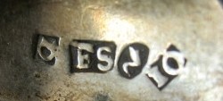
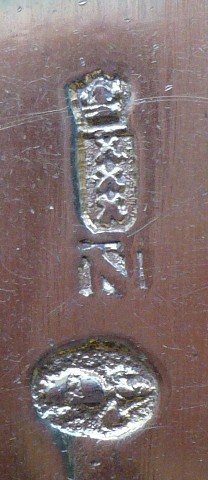
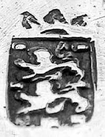
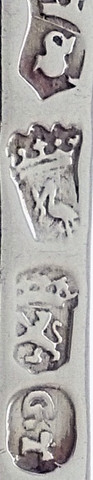
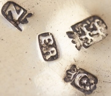
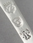
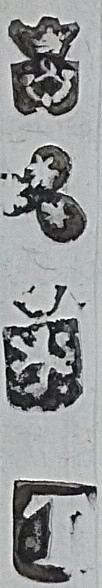
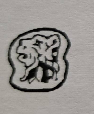
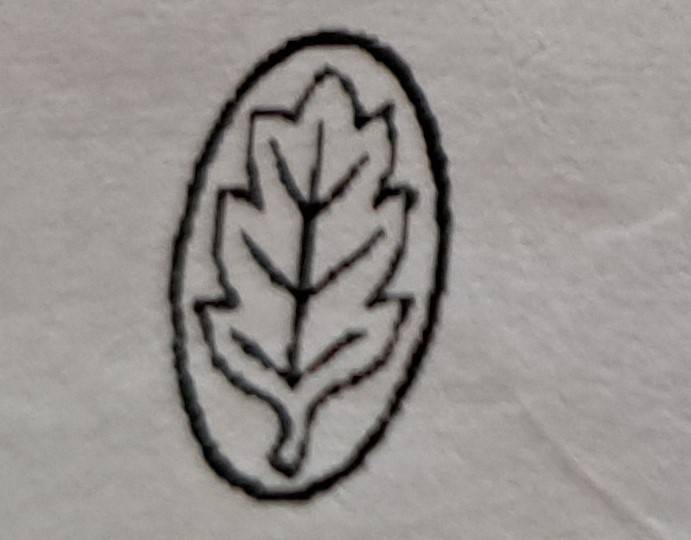
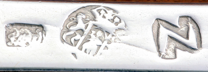
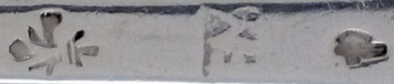
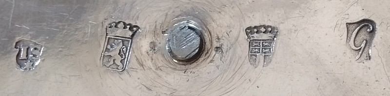
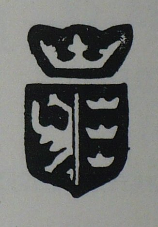
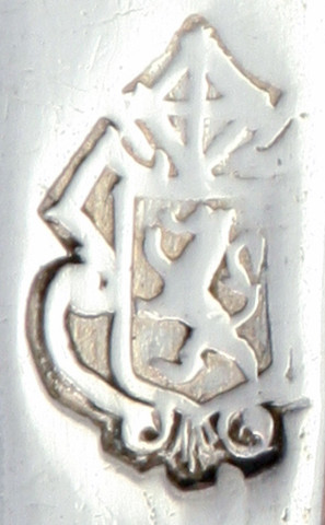
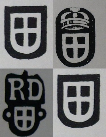
The town mark of Middelburg is based on the coat of arms: a double-headed (crowned) eagle in a shield. There are various versions of the city mark known. Makers mark LP gentleman for; Lodewijk Potmans, registered 1774-1797, double-headed eagle with date letter combined K= 1773-1775. Reference book; J. de Bree Zeeuws Zilver.
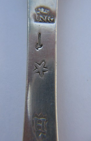
Town mark for the city of Middelburg, used 2nd half 18th century, 2nd standard or coin silver being 10 penningen 16 greinen (889/1000), year letter G for 1770. Maker's mark GS under a star for for Gerard Stertzenbach registered in Middelburg 1753-1786.
City of Nijmegen.
. Nijmegen, historically anglicized as Nimeguen, is a municipality and a city in the Dutch province of Gelderland. It is situated on the Waal River, close to the German border. Nijmegen is among the three oldest cities in the Netherlands. The first mention of Nijmegen in history is in the 1st century BC, when the Romans built a military camp on the place where Nijmegen was to appear; the location had great strategic value because of the surrounding hills, which gave (and continue to give) a good view over the Waal and Rhine valley. By 69, when the Batavians, the original inhabitants of the Rhine and Maas delta, revolted, a village called Oppidum Batavorum had formed near the Roman camp. This village was destroyed in the revolt, but when it had ended the Romans built another, bigger camp where the Legio X Gemina was stationed. Soon after, another village formed around this camp.In 98, Nijmegen was the first of two settlements in what is now the Kingdom of the Netherlands to receive Roman city rights. In 103, the X Gemina was re-stationed to Vindobona, modern day Vienna, which may have been a major blow to the economy of the village around the camp, losing around 5000 inhabitants. In 104 Emperor Trajan renamed the town, which now became known as Ulpia Noviomagus Batavorum, Noviomagus for short (the origin of the current name Nijmegen). Beginning in the second half of the 4th century, Roman power decreased and Noviomagus eventually became part of the Frankish kingdom. It has been contended that in the 8th century Emperor Charlemagne maintained his palatium in Nijmegen on at least four occasions. During his brief deposition of 830, the emperor Louis the Pious was sent to Nijmegen by his son Lothar I. Thanks to the Waal river, trade flourished. The powerful Henry VI, Holy Roman Emperor was born at Nijmegen in 1165. In 1230 his son Frederick II, Holy Roman Emperor granted Nijmegen city rights. In 1247, the city was ceded to the count of Guelders as collateral for a loan. The loan was never repaid, and Nijmegen has been a part of Gelderland ever since. This did not hamper trade; Nijmegen even became part of the Hanseatic League in 1364. The arts also flourished in this period. Famous medieval painters like the Limbourg brothers were born and educated in Nijmegen. During the Dutch Revolt, trade came to a halt and even though Nijmegen became a part of the Republic of United Provinces in 1585, it remained a border town and had to endure multiple sieges. In 1678 Nijmegen was host to the negotiations between the European powers that aimed to put an end to the constant warfare that had ravaged the continent for years. The result was the Treaty of Nijmegen that, unfortunately, failed to provide for a lasting peace. In the second half of the 19th century, the fortifications around the city became a major problem. There were too many inhabitants inside the walls, but the fortifications could not be demolished because Nijmegen was deemed as being of vital importance to the defence of the Netherlands. When events in the Franco-Prussian war proved that old-fashioned fortifications were no more of use, this policy was changed and the fortifications were dismantled in 1874. The old castle had already been demolished in 1797, so that its bricks could be sold. Through the second half of the 19th century and the first half of the 20th century, Nijmegen grew steadily. The Waal was bridged in 1878 by a rail bridge and in 1936 by a car bridge, which was claimed to be Europe's biggest bridge at the time. In 1923 the current Radboud University Nijmegen was founded and in 1927 a channel was dug between the Waal and Maas rivers.
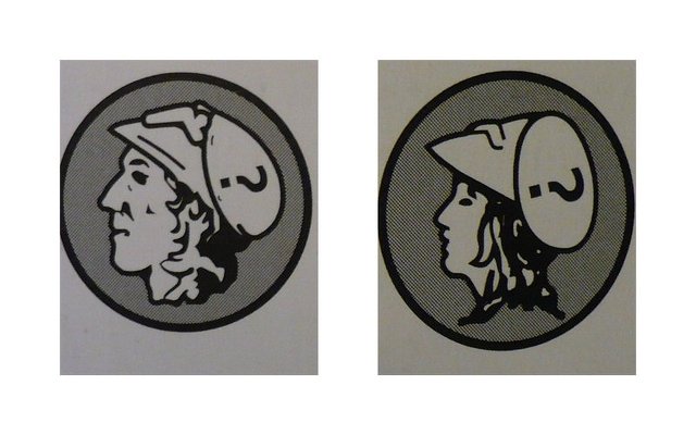
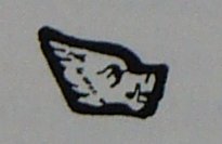
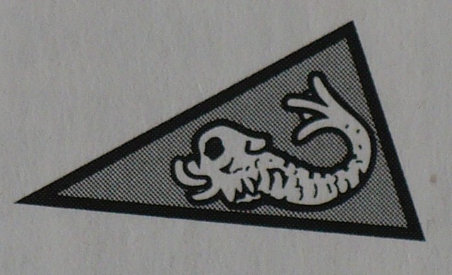
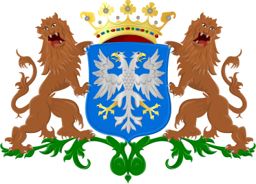
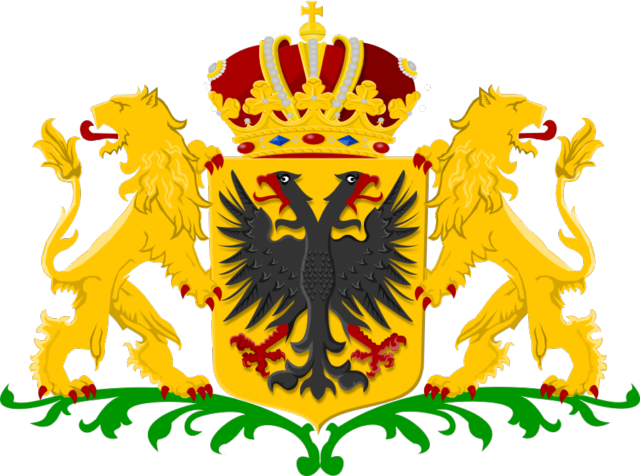
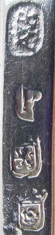
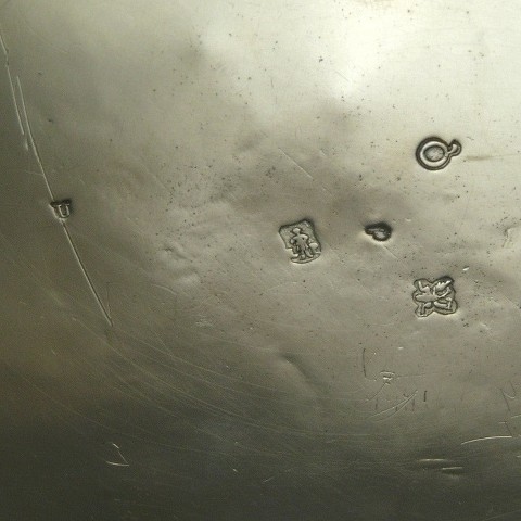
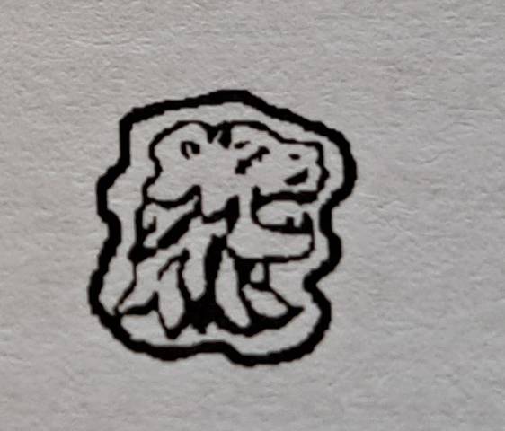
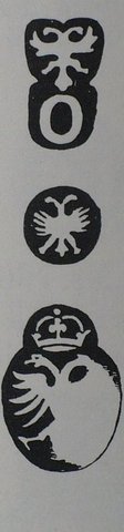
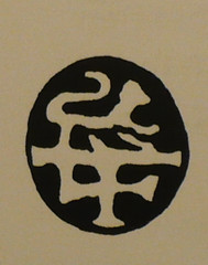
Double-headed eagle, the town mark of Nijmegen based on the coat of arms, in connection with the Holy Roman (German) Empire. As a trading centre, Nijmegen gained increasing importance. In 1230, the Holy Roman Emperor Henry VII granted a charter to its inhabitants and so Nijmegen became a ‘free German imperial city’ in the Holy Roman Empire. The double-headed eagle and the emperor’s crown in Nijmegen’s coat of arms are remnants of this era.
Makers mark SS for: Severijn Schiff, registered 1762-1802, Nijmegen double-headed-eagle, N in a crowned shield for Nijmegen 1st standard silver, date letter A for 1792.
City of Roermond.
. Roermond, a municipality, and a diocese in the south-eastern part of the Netherlands. The city of Roermond is a historically important town, on the lower Roer at the east bank of the Meuse river. It received city rights in 1231. Roermond town centre has been designated as a conservation area. Through the centuries the town has filled the role of commercial centre, principal town in the duchy of Guelders and since 1559 it has served as the seat of the Roman Catholic Diocese of Roermond. The skyline of the historic town is dominated by the towers of its two churches: St. Christopher Cathedral and Roermond Minster or 'Munsterkerk' in Dutch. In addition to important churches, the town centre has many listed buildings and monuments. Around 1180–1543, Roermond belonged to the duchy of Guelders. In 1213 Roermond was destroyed by Otto IV of Brunswick, the Holy Roman Emperor and German King. By 1232 the city had been rebuilt, and was given its own seal, own reign, own mint, and its own court. The first mention of the monastery of the Franciscan Friars Minor, the Minderbroederklooster, was in 1309. In 1361, the Chapter of the Holy Spirit moved from St. Odiliënberg to Roermond. Around 1350, Roermond became the capital of the "Overkwartier van Gelre" (Upper Quarter of Gelre). In 1388, during the Hundred Years' War, a siege by the French occurred. A battle for the outer fortifications Buiten Op, destruction of these fortifications and the old parish church followed. In 1441, Roermond became a member of the Hanseatic League, and by 1472 acquired the right to mint its own coins. Between 1543–1702 the area was part of the Spanish Netherlands. On 23 April 1568 the Battle of Rheindalen occurred near Roermond, which signaled the start of the Eighty Years' War. In 1572, Roermond was occupied by the Dutch William the Silent, but recaptured by the Spanish duke Fadrique Álvarez de Toledo. Under Spanish rule Roermond became a bastion of the Counter-Reformation. On behalf of the Inquisition people were encouraged to report suspects of witchcraft and heresy. In 1613, 64 presumed witches were burnt on the Galgeberg hill near the Kapel in het Zand in Roermond, the biggest witch trial in the Netherlands ever. In 1632 the Dutch Stadhouder Frederik Hendrik conquered Venlo, Roermond and Maastricht during his famous "March along the Meuse". Attempts in the next years to annex Antwerp and Brussels failed, however. The northern Dutch were disappointed by the lack of local support. The Counter-Reformation had firmly reattached the local population to Roman Catholicism, and they now distrusted the Calvinist Northerners even more than they loathed the Spanish occupiers. Between 1632 and 1637, Roermond was under the control of the Dutch Republic, and again from 1702 to 1716. Between 1716 and 1794, it was part of the Austrian Netherlands within the Habsburg Monarchy. On 11 December 1792, during the French Revolutionary Wars, the French under General De Miranda conquered Roermond, but by 5 March 1793, was under Habsburg control again. The city was again occupied by the French on 5 April 1794 and officially became part of the French département Meuse-Inférieure from 1795 to 1814. In 1814, during the War of the Sixth Coalition Roermond was liberated by the Russians. After the Anglo-Dutch Treaty of 1814 Roermond became part of the new Kingdom of the Netherlands. The new province was to receive the name "Maastricht", after its capital. King William, who did not want the name Limburg to be lost, insisted that the name be changed to Limburg. As such, the name of the new province derived from the old duchy of Limburg that had existed until 1648 within the triangle Maastricht – Liège – Aachen. When the Netherlands and Belgium separated in 1830, there was support for adding Limburg to Belgium, but in the end (1839) the province was divided in two, with the eastern part going to the Netherlands and the western part to Belgium. From that time, Dutch Limburg was, as the new Duchy of Limburg, also part of the German Confederation.
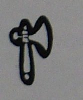
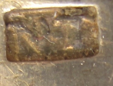
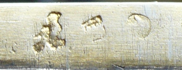
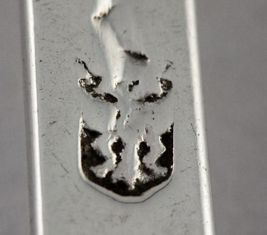
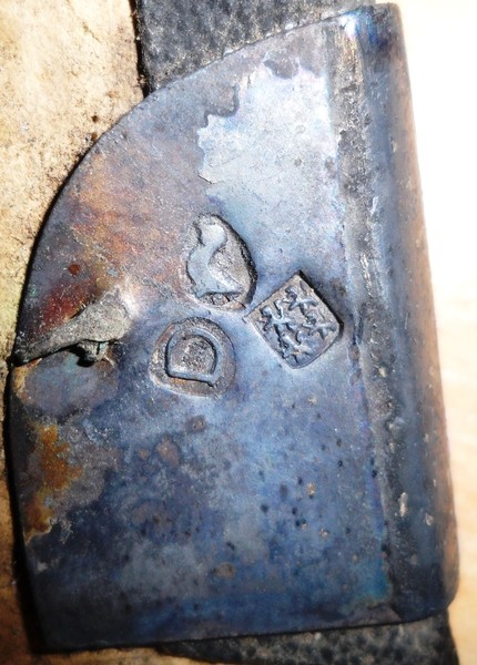
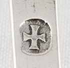
. Town mark of Roermond, a fleur de Lis is based on the coat of arms
Town mark of Roermond, makers’ mark FM for: Franciscus D. Matthei, registered 1764-1786, and a later tax mark, the hatchet, the 1853 duty mark for old silver objects of national origin returned to the trade. We assume Roermond used only 1st standard silver and never used year-letters.
City of Rotterdam.
. Rotterdam is a city in South Holland, the Netherlands, located geographically within the Rhine–Meuse–Scheldt river delta at the North Sea. Its history goes back to 1270 when a dam was constructed in the Rotte river and people settled around it for safety. In 1340 Rotterdam was granted city rights by the Count of Holland and slowly grew into a major logistic and economic centre. The settlement at the lower end of the fen stream Rotte (or Rotta, as it was then known, from rot, 'muddy' and a, 'water', thus 'muddy water') dates from at least 900 CE. Around 1150, large floods in the area ended development, leading to the construction of protective dikes and dams, including Schielands Hoge Zeedijk ('Schieland’s High Sea Dike') along the northern banks of the present-day Nieuwe Maas. A dam on the Rotte or 'Rotterdam' was built in the 1260s and was located at the present-day Hoogstraat ('High Street'). On 7 July 1340, Count Willem IV of Holland granted city rights to Rotterdam, which then had approximately 2,000 inhabitants. Around the year 1350, a shipping canal, the Rotterdamse Schie was completed, which provided Rotterdam access to the larger towns in the north, allowing it to become a local trans-shipment centre between the Netherlands, England and Germany, and to urbanize. The port of Rotterdam grew slowly but steadily into a port of importance, becoming the seat of one of the six 'chambers' of the Vereenigde Oostindische Compagnie (VOC), the Dutch East India Company. The greatest spurt of growth, both in port activity and population, followed the completion of the Nieuwe Waterweg in 1872. The city and harbor started to expand on the south bank of the river. The Witte Huis or White House skyscraper, inspired by American office buildings and built in 1898 in the French Chateau-style, is evidence of Rotterdam's rapid growth and success. When completed, it was the tallest office building in Europe, with a height of 45 m (147.64 ft).
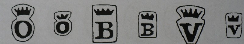
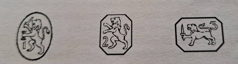
Town mark for Rotterdam; 4 lion's passant facing left in four quarters above vertical bar in a crowned shield.
https://www.heraldry-wiki.com/heraldryw ... =Rotterdam
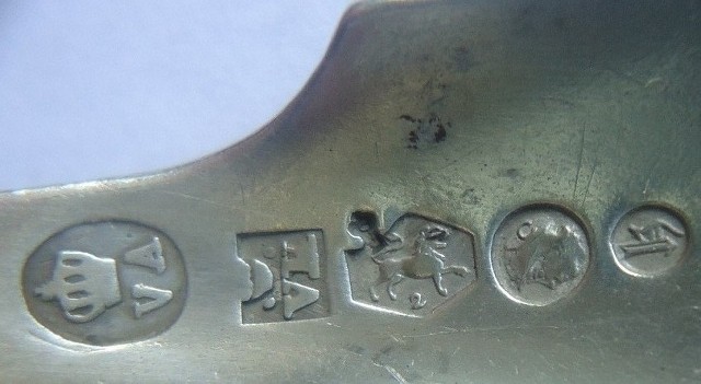
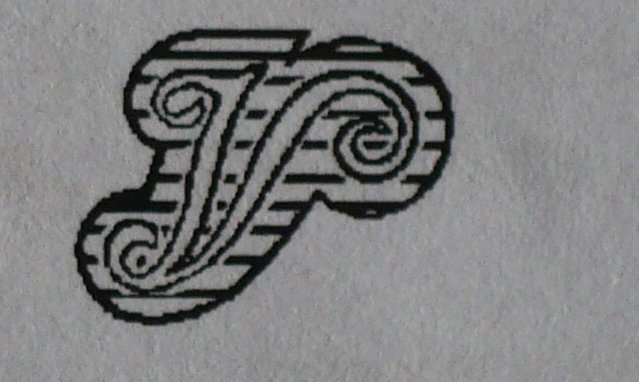
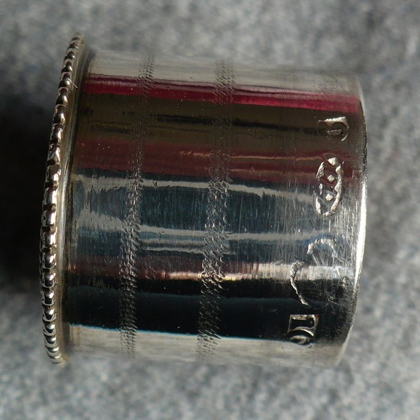
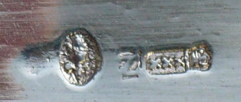
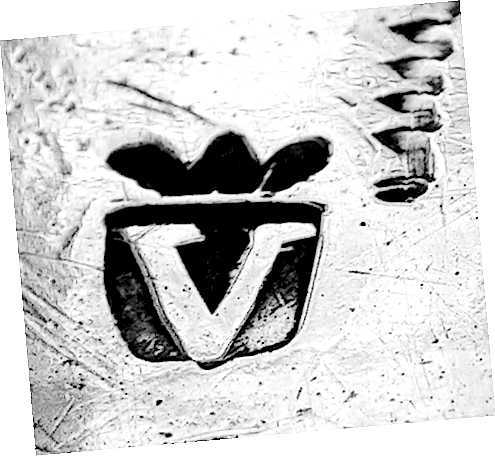
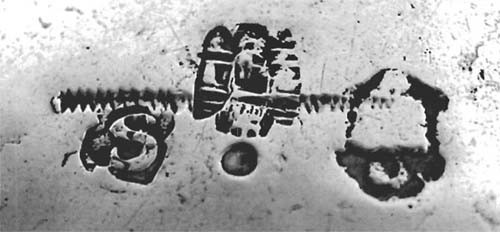
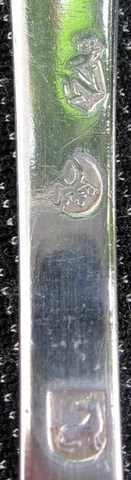
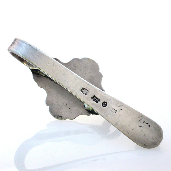
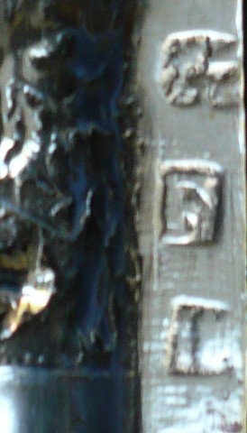
Rotterdam city town mark variant 1785-1790, master's mark DB for: Abraham du Breuil, registered in Rotterdam during 1787-1811. Rotterdam used big and small year letters. The small year letters come in an oval shield. Gothic g for; 1789 (rotated 180 degrees). The other marks are the V in crowned shield, tax mark used 1814-1893 and the last vague mark (right hand corner) most likely the lion rampant in crowned shield or 1st standard province mark to indicate .934 fineness.
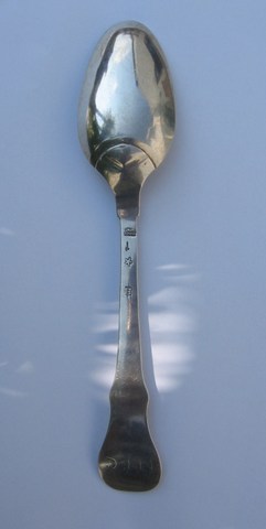
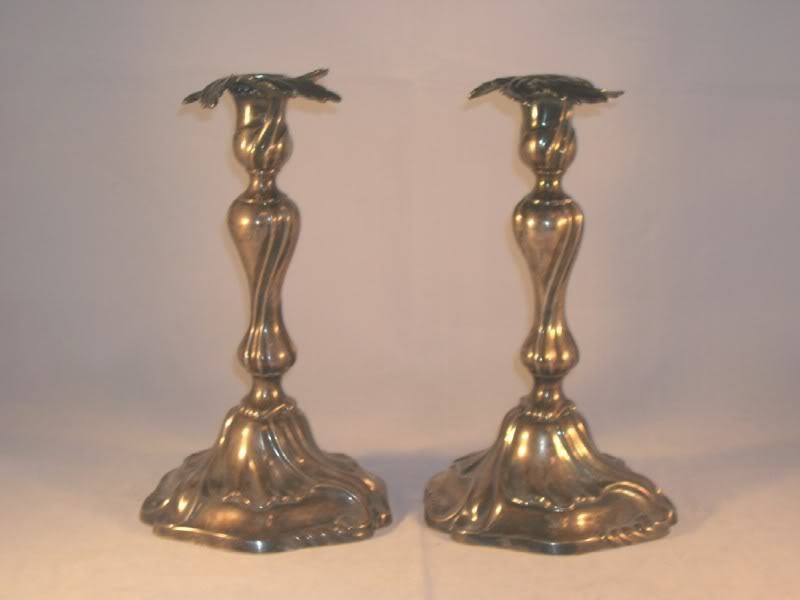
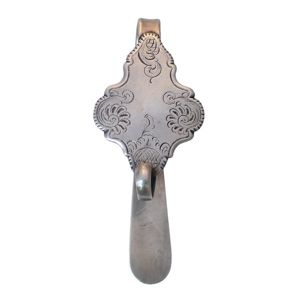
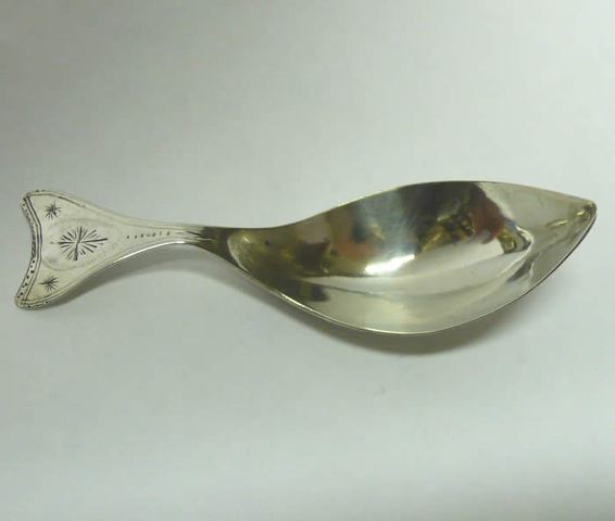
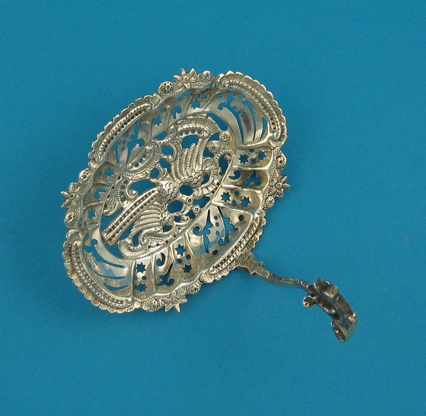
Caddy spoon Rotterdam
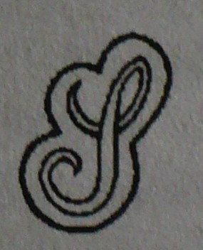
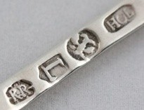
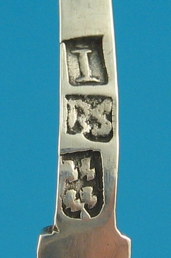
Crowned V for large items; duty mark for foreign and other untaxed objects used 1814-1893. This duty mark does not give any guarantee of a precious metal standard of fineness. This mark has been used on metal with a 250 minimum silver content as a duty mark. This mark was destined for all imported, unmarked and invalid marked objects of foreign, national and unknown origin. Upon the invalidation of the hallmarks of Louis Napoleon's kingdom of Holland and those of the French Empire in 1816, this mark also has been used as a tax free census mark. Year-letter IJ for Rotterdam 1805, Town mark Rotterdam, maker’s mark
PI for: Pieter Janse(n) (born1779- registered till around 1816). 2nd standard silver, no lion rampant.
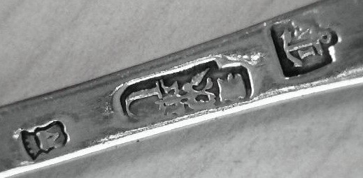
The maker's mark is IS above a star for; Johannes Jansen (I*S) registered in Rotterdam 1773-1818, followed by the standard province mark the lion rampant in a crowned shield 934/000 fineness, the town mark of Rotterdam; 4 lion's passant facing left in four quarters above vertical bar in a crowned shield.The year letter script G for 1789.
City of Schoonhoven.
.Schoonhoven is a city and former municipality in the western Netherlands, in the province of South Holland. Circa 1220 a castle was built on the north side of little stream Zevender, near its mouth at the Lek River and Schoonhoven formed near the castle. The oldest reference to Schoonhoven is on a document from 1247 where the town is called Sconhoven. In 1280, it was granted city rights. Around 1350, the city walls and gates were added to Schoonhoven. Its economy was dependent on shipping, brewing, fishing and agriculture. Schoonhoven was also the marketplace for the region. In 1518 the castle burned down and its remnants were removed in subsequent decades. Between 1582 and 1601 the city's defense walls were renewed and expanded to include the shipyards as well. And following the Disaster Year of 1672, they were reinforced again and expanded on the west and north sides.
https://en.wikipedia.org/wiki/Rampjaar
Yet in 1816, when bastion fortifications were no longer relevant to the warfare of the time, they were mostly demolished and made way for a cemetery and park.In 1860 the city had 2900 inhabitants. Schoonhoven is renowned for its silver, hence it is nicknamed Zilverstad ("Silver City"). Since the 17th century silver smiths have already been present here. Today there are a lot of silver trade possibilities and Schoonhoven is home of the Nederlands Zilvermuseum(Dutch Silver Museum) and the International Silver School. Another less known tradition in Schoonhoven is that of clock making. There are still small scale clock makers. Some of them can be visited. A beautiful example of large clockwork is the Van den Gheyn Beiaard on the medieval town hall of Schoonhoven.
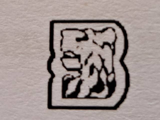
Shield with rounded base with four lions rampant facing left; the guild city mark of
Schoonhoven; for 2nd standard silver or
Kleine keur 83.3% pure silver used. The city mark with rounded shield base for 2nd quarter 18th century.
The maker's mark a standing Jackdaw (small crow) has been attributed to: Anthony van der Kaa, he started around 1725-1729, died 1747. Year letter D for 1734. Source; Zilver Histograaf Schoonhoven, jaargang 2022, afl.4
https://zilverhistograaf.nl/zh/wp-conte ... cember.pdf
Marks found on; Dutch State Bible (Statenbijbel), silver plates & clasps.
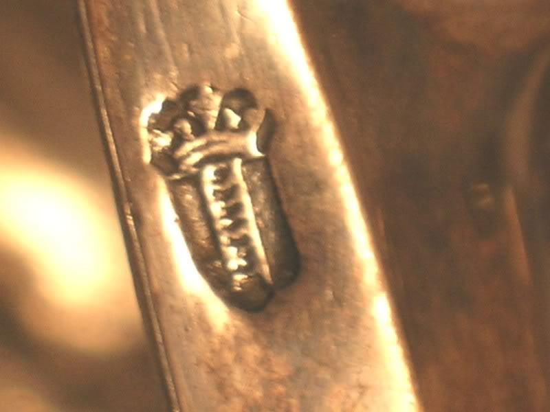
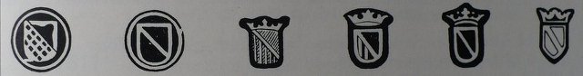
NB.The city mark of Schoonhoven is notoriously unclear, and always without a crown and based upon for lions rampant and with many variations, see variations Schoonhoven city marks used 1802-1804:
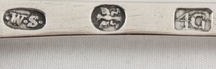
Town mark Schoonhoven for 1778-1781, year letter F for 1779, maker’s mark IM for Jan Mesman, registered 1769 till around 1806. Known maker of snuff boxes. He later run a grocery shop.
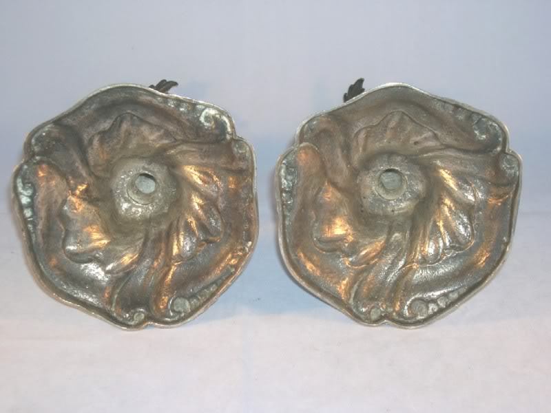
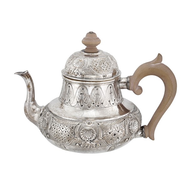
Silver sifter made by Bartholomeus Smits
Year letter I for 1782, makers mark BS for: Bartholomeus Smits registered 1756-1803, town mark Schoonhoven.
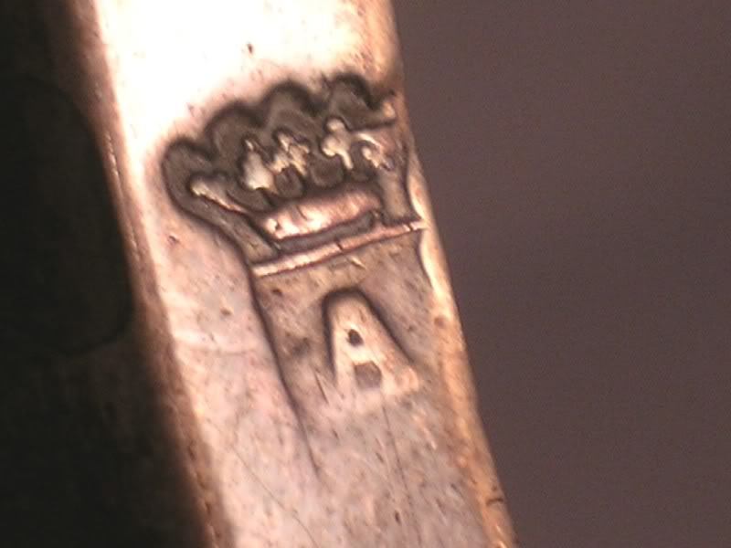
Teapot, for me the first I see with the town mark for Schoonhoven. Master's mark GK for Gerard Koen, started in Schoonhoven in 1741 until his death in 1778. Apprentice in Haarlem from 1736 to 1741. Year letter N, with serifs, given the Dutch lion (see Silversmiths of the city of Schoonhoven page 165 # 41), N=1743
City of Sneek.
. Sneek ; (West Frisian: Snits) is a city southwest of Leeuwarden and seat of the former municipality of Sneek in the province of Friesland (Netherlands). As for 2011 it is part of the municipality Súdwest Fryslân. The city has approximately 33,000 inhabitants. Sneek is situated in Southwest-Friesland, close to the Sneekermeer(lake) and is well known for its canals, the Waterpoort (Watergate, the symbol of the city), and watersport (Sneekweek). Sneek is one of the Friese elf steden (Eleven cities). The city is very important for the southwest area of Friesland (the "Zuidwesthoek").
Sneek was founded in the 10th century on a sandy peninsula at the crossing site of dike with an important waterway (called the Magna Fossa in old documents). This waterway was dug when the former Middelzee silted up. The dike can still be traced in the current street pattern and street names like "Hemdijk", "Oude Dijk" and "Oosterdijk". Sneek received several city rights in the 13th century, which became official in 1456. Sneek was now one of the eleven Frisian cities. This was also the beginning of a period of blooming trade for the city that would last until about 1550. In 1492 construction of a moat and wall around the city began. In those days Sneek was the only walled city in Friesland. The waterpoort and the bolwerk remain today.
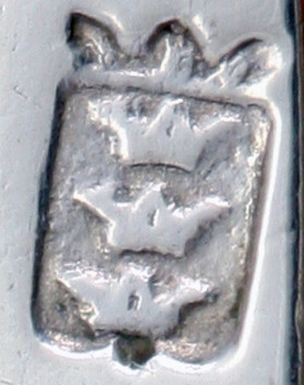
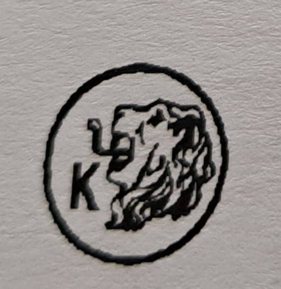
. Sneek town mark: three superposed crowns and as of 1749 in a crowned shield.
From 1764 the town mark is changed. The town mark is base on the city coat of arms; a divided crowned shield, at the left the Frisian eagle and on the right three crowns.
. Town mark of Sneek, makers mark a clover &crown for: Johannes de Vries, registered 1735-1769, province mark Friesland, 1st standard silver 934/1000, date letter R for: 1752
City of Utrecht.
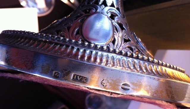
. Utrecht is the capital and most populous city in the Dutch province of Utrecht. Utrecht's ancient city centre features many buildings and structures several dating as far back as the High Middle Ages. It has been the religious center of the Netherlands since the 8th century. Utrecht was the most important city in the Netherlands until the Dutch Golden Age, when it was succeeded by Amsterdam as the country's cultural center and most populous city.In 1579 the northern seven provinces signed the Union of Utrecht, in which they decided to join forces against Spanish rule. The Union of Utrecht is seen as the beginning of the Dutch Republic. In 1580 the new and predominantly Protestant state abolished the bishoprics, including the archbishopric of Utrecht. The stadtholders disapproved of the independent course of the Utrecht bourgeoisie and brought the city under much more direct control of the republic; which shifted the power towards its dominant province Holland. This was the start of a long period of stagnation of trade and development in Utrecht. Utrecht remained an atypical city in the new republic with about 40% Catholic in the mid-17th century, and even more among the elite groups, who included many rural nobility and gentry with town houses there. The fortified city temporarily fell to the French invasion in 1672 (the Disaster Year); where the French invasion was only stopped west of Utrecht at the Old Hollandic Waterline. In 1674, only two years after the French left, the centre of Utrecht was struck by a tornado. In 1713, Utrecht hosted one of the first international peace negotiations when the Treaty of Utrecht settled the War of the Spanish Succession. Since 1723 Utrecht became the centre of the non-Roman Old Catholic Churches in the world. The silver guild town mark of the city of Utrecht is based on the city coat of arms: a crowned cross-divided coat of arms meets with vertical stripes in the vertical section.
. Hatchet,later tax mark, makers mark AVG for: Adrianus van Gelder, registered 1784-1811, Utrecht town mark struck twice to indicate 1st standard silver. (town mark + province mark of Utrecht), year letter H for 1791
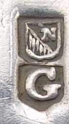
In 1739 the 2nd standard mark introduced, the meaning of the letter N, top right shield is not known.Combined town mark Utrecht and date letter G for:1790
City of Vlissingen (Flushing).
. Vlissingen; Zeelandic: Vlissienge; historical name in English: Flushing is a municipality and a city in the southwestern Netherlands on the former island of Walcheren. With its strategic location between the Scheldt river and the North Sea, Vlissingen has been an important harbor for centuries. It was granted city rights in 1315. In the 17th century Vlissingen was a main harbor for ships of the Dutch East India Company (VOC). It is also known as the birthplace of Admiral Michiel de Ruyter. The fishermen’s hamlet that came into existence at the estuary of the Schelde around AD 620 has grown over its 1,400-year history into the third-most important port of the Netherlands. The Counts of Holland and Zeeland had the first harbours dug. Over the centuries, Vlissingen developed into a hub for fishing, especially the herring fishery, commerce, privateering and the slave trade. During the heyday of the Dutch Golden Age, ships from Vlissingen set sail for the various outposts of the Dutch colonial empire and contributed to the world power of The Seven Provinces. The derivation of the name Vlissingen is unclear, though most scholars relate the name to the word fles (bottle) in one way or another. According to one story, when saint Willibrord landed in Vlissingen with a bottle in the 7th century, he shared its contents with the beggars he found there while trying to convert them. A miracle occurred, familiar to readers of hagiography, when the contents of the bottle did not diminish. When the bishop realised the beggars did not want to listen to his words, he gave them his bottle. After that, he supposedly called the city Flessinghe. Another source states that the name had its origins in an old ferry-service house, on which a bottle was attached by way of a sign. The monk Jacob van Dreischor, who visited the city in 967, then apparently called the ferry-house het veer aan de Flesse (the ferry at the Bottle). Because many cities in the region later received the appendix -inge, the name, according to this etymology, evolved to Vles-inge. According to another source, the name was derived from the Danish word Vles, which means tides.The eastern cape of Novaya Zemlya, Cape Flissingsky was named after the city in 1596 by Willem Barentsz. Vlissingen was historically called "Flushing" in English. In the 17th century
Vlissingen was important enough to be a town that English speakers referred to and that had acquired its own English name. For example, Samuel Pepys referred to the town as "Flushing" in his diaries. In 1673 Sir William Temple referred to Vlissingen as "Flushing" once and "Flussingue" twice in his book about the Netherlands.] Some English writers in the Netherlands also used the Dutch name.Flushing, originally a Dutch colonial village and now part of Queens, New York City, was first called Vlissingen after the town in the Netherlands. The English settlers who also came to live in the village[6] shortened the name to "Vlissing" and then began to call it by its English name, Flushing, and this continued and grew after the conquest of New Netherland. The corruption of "Vlissingen" into "Flushing" did not occur after the conquest of New Netherland, but in England well before then. This village was the site of the Flushing Remonstrance. The village of Flushing in Cornwall was also named after Vlissingen. Originally named Nankersey, the village was given its name by Dutch engineers from Vlissingen in the Netherlands who built the three main quays in the village.
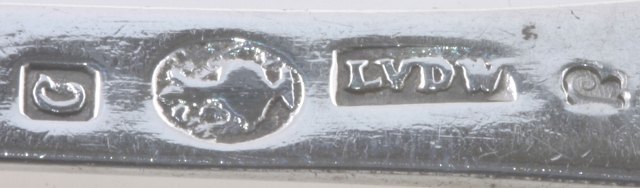
Town mark of Vlissingen
.
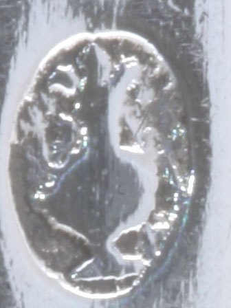
Vlissingen,year letter C for; 1786, town mark, bottle in oval for Vlissingen and makers mark LVDW for: Lambrecht van der Woord, registered 1780-...?, and later tax mark.
City of Woerden.
. Woerden is a city and a municipality in the central Netherlands, central located between Amsterdam, Rotterdam. The river Oude Rijn used to flow through the city center of Woerden, but in 1960 the old river was diverted around the city center. The city has a long and rich history in cheese making and trading; for years Gouda cheese for domestic and international use has been produced in this region. Woerden still holds its authentic (since 1885) cheese market at the market place in its center. The reign of Charles V was a period of relative peace and prosperity for Woerden, despite religious unrest. In April 1522 Charles V introduced the Inquisition in the Low Countries. Johannes Pistorius Woerdensis (Jan de Bakker), a catholic priest, was the first preacher in the Northern Netherlands to be martyred as a direct result of his religious beliefs. The city magistrates of Woerden were tolerant towards the Lutheran confession. In 1566 this resulted in a confrontation with duke Eric of Brunswick, who was Lord of Woerden at that time. In later history, the town saw occupation by the Spanish (1575, 1576) and the French (1672, 1673 and particularly disastrous in 1813).
. Town mark Woerden based on the coat of arms.
Woerden makers mark VG for: Johan van Genderen, registered 1792-1807, unclear town mark of Woerden, year letter C for; 1801
City of Zierikzee
.
Zierikzee is a small city, located on the former island of Schouwen in the Dutch province of Zeeland. It is a part of the municipality of Schouwen-Duiveland, and lies about 26 km southwest of Hellevoetsluis. Zierikzee received city rights in 1248 and was an independent municipality until 1997.
.
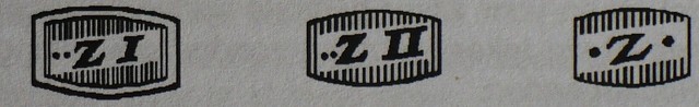
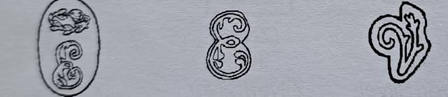
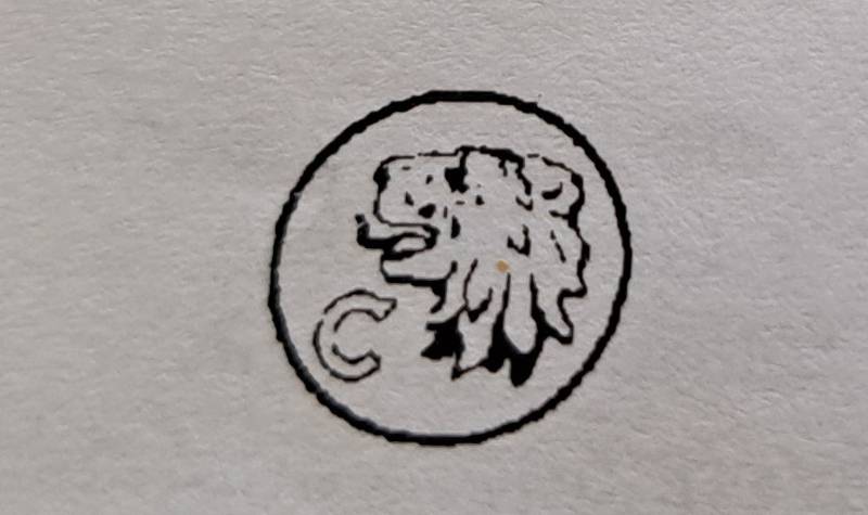
Until 1737 town mark from Zierikzee was indicated by a crowned letter Z.
.
Town mark of Zierikzee based on coat of arms, as of 1737. From 1737 the town mark was replaced by a lion rampant going left, in a shield flanked by the letter "Z" and surmounted by a cross in a square.
.
Makers mark IE crowned for; Jan Eyermeet 1718…..?, town mark Zierikzee, year letter W, around 1750, unfortunately not much is known about those year letters.
City of Zwolle.
.
Zwolle is a municipality and the capital city of the province of Overijssel, Netherlands. Archaeological findings indicate that the area surrounding Zwolle has been inhabited for a long time. A woodhenge that was found in the Zwolle-Zuid suburb in 1993 was dated to the Bronze Age period. During the Roman era, the area was inhabited by Salian Franks.
The modern city was founded around 800 A.D. by Frisian merchants and troops of Charlemagne.[8] The name Zwolleis derived from the word Suolle, which means "hill" (cf. the English cognate verb "to swell"). This refers to an incline in the landscape between the four rivers surrounding the city, IJssel, Vecht, Aa and Zwarte Water. The hill was the only piece of land that would remain dry during the frequent floodings of the rivers. Zwolle was established on that incline.
A document mentions the existence of a parish church dedicated to St Michael. That church, the Grote or Sint Michaëlskerk (big or Saint Michael Church), was renovated in the first half of the 15th century and exists to this day. The church contains a richly carved pulpit, the work of Adam Straes van Weilborch (about 1620), some good carving and an exquisite organ (1721).
On August 31, 1230, the bishop of Utrecht granted Zwolle city rights. Zwolle became a member of the Hanseatic league in 1294, and in 1361 joined the war between the Hanseatic League and Valdemar IV of Denmark. In the 1370 Treaty of Stralsund that ended the war, Zwolle was awarded a vitte, a trade colony, in Scania, then part of Denmark. Zwolle's golden age came in the 15th century. Between 1402 and 1450, the city's Gross Regional Product multiplied by about six.In the 15th century Zwolle develops into one of the most powerful cities of Hanseatic League.
In July 1324 and October 1361, regional noblemen set fire to Zwolle. In the 1324 fire, only nine buildings escaped the flames. Zwolle was also, with Deventer, one of the centers of the Brethren of the Common Life, a monastic movement. Three miles from Zwolle, on a slight eminence called the Agnietenberg, (hill of St Agnes), once stood the Augustinian convent in which Thomas à Kempis spent the greatest part of his life and died (in 1471). Zwolle had a considerable trade by river, a large fish market, and the most important cattle market in the Netherlands after Rotterdam. The more important industries comprised cotton manufactures, iron works, boat-building, dyeing and bleaching, tanning, rope-making, and salt-making.
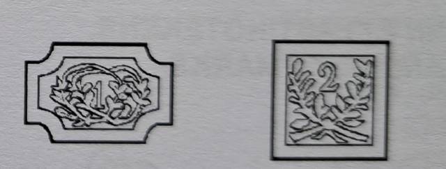
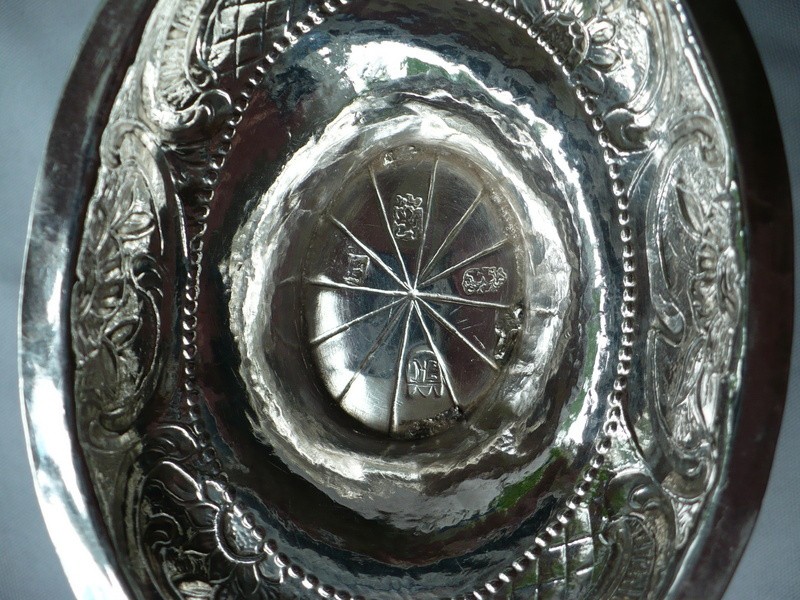
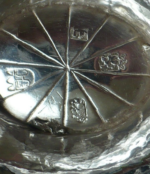
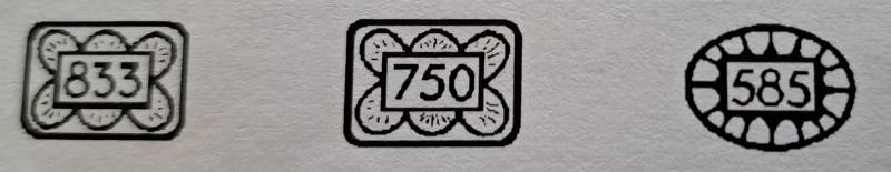
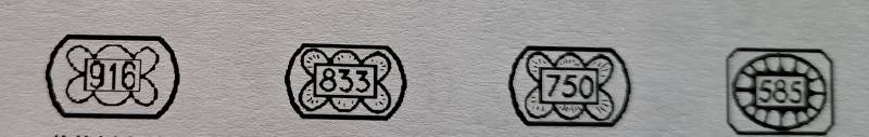
The town mark of Zwolle is based on the coat of arms.Town mark Zwolle crowned for 1st standard or “grote keur”934/1000 and town mark without crown, 3rd standard silver 833/1000 fineness.
Town mark with R.D short for ‘Rijks Daalder’(coinsilver) 892/1000 fineness, 2nd standard.
Zwolle R.D. 2nd standard silver 892/1000, ,masters mark a ship with sails for: Willem Hermen Wenink, registered 1792-1811, year-letter T for 1782-1783.
The Zwolle year letters
A 1644- Z 1667 no mark above the letters of the series
A 1668- Z 1691 no mark above the letters of the series
A 1692- Z 1715 a five-petalled rose above the letters of the series
A 1716- Z 1739 a comma or number 1 above the letters of the series
A 1740- Z 1763 the number 2 above the letters of the series
A 1764- Z 1787 no mark above the letters of the series
A 1788- V 1807 a dot above the letters of the series (end of guild period)
It must be noted that the I and the J and the U and the V each form 1 letter.
City of Zutphen.
. Zutphen is a town in the province of Gelderland in the Netherlands. It lies some 30 km north-east of Arnhem, on the Eastern bank of the river IJssel at the point where it is joined by the Berkel. The name Zutphen (first mentioned in the eleventh century) appears to mean 'zuid-veen', or in English, south-fen. About 300 AD a Germanic settlement was the first permanent town on a complex of low river dunes. Whereas many such settlements were abandoned in the early Middle Ages, Zutphen on its strategic confluence of IJssel and Berkelstayed. After the incorporation of the IJssel lands in Charlemagne's Francia, Zutphen became a local centre of governance under a count. The Normans raided and ravaged it in 882. Afterwards a circular fortress was built to protect the budding town against Viking attacks. In the eleventh century Zutphen was a royal residence for a number of years; a pfalz was built, together with a largechapter church, the predecessor of the present St. Walburgis. The counts of Zutphen acquired a lot of power, until the line of counts became extinct in the twelfth century. After the death of her father and her brother, Ermgard, the heiress of Zutphen married the count of Guelders; her son Henry I, Count of Guelders was the first to wear both titles.The settlement received town rights between 1191 and 1196, making it one of the oldest towns in the country. This allowed it to self govern and have a judicial court. Only Utrecht, and Deventer preceded it in receiving town rights. Zutphen, in turn, became the mother town of several other towns in Guelders, such as Arnhem, Doetinchem,Doesburg, Lochem, Harderwijk, Venlo and Emmerich. It also became part of the Hanseatic League, a group of towns with great wealth; this league was the economic centre in that part of Europe. During the 12th century coins were minted in Zutphen by the Counts of Guelders and Zutphen: Henry I (circa 1150-1181) and Otto I (1182-1207). Although the city had minting rights for a few centuries this was only actively used during four periods: 1478-1480, 1582-1583, 1604-1605 and 1687-1692. The largest and oldest church of the city is the St. Walburgis (Saint Walpurga) church, which originally dates from the eleventh century. The present Gothic building contains monuments of the former counts of Zutphen, a fourteenth-century candelabrum, an elaborate copper font (1527), and a monument to the Van Heeckeren family (1700). The chapter-house of library ("Librije") contains a pre-Reformation library which includes some valuable manuscripts andincunabula. It is considered one of only 5 remaining medieval libraries in Europe (the other 4 being in England and Italy). The old books are still chained to their ancient wooden desk, a habit of centuries ago, dating from the times when the library was a "public library" and the chains prevented the books from being stolen. Having been fortified the town withstood several sieges, specially during the wars of freedom waged by the Dutch against Spain, the most celebrated fight under its walls being the Battle of Zutphen in September 1586 when Sir Philip Sidney was mortally wounded. Taken by the Spanish in 1587 by the treachery of the English commander Rowland York, Zutphen was recovered by Maurice, prince of Orange, in 1591, and except for two short periods, one in 1672 and the other during the French Revolutionary Wars, it has since then remained a part of the Netherlands. Its fortifications were dismantled in 1874. In World War II the town was bombed several times by the allied forces because the bridge over the IJssel was vital to support the German troops at Arnhem after the Operation Market Garden. After two weeks of battle the town was liberated on the 14th of April 1945. After the war a renovation program started. Nowadays Zutphen has one of the best preserved medieval town centres of North-Western Europe, including the remains of the medieval town wall and a few hundred buildings dating from the 13th - 15th century.
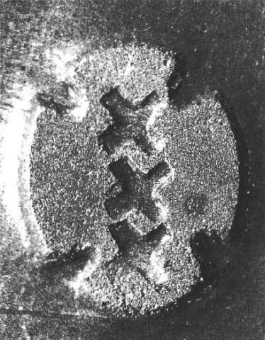
Town mark of Zuthpen, Greek cross, based on the coat of arms, for 2nd standard silver. Town mark Zutphen,Greek cross under a lion passant, facing right for 1st standard silver 934/000, not often seen.
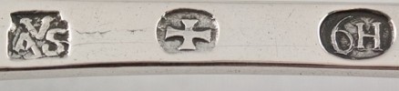
Makers mark AVS for: Anthony van Sandbergen registered 1770-1800, town mark Zutphen for 2nd standard silver , date letter 6th alphabet H=1782. After his death in 1800 his widow continued to use the AVS mark 1800-1807.
Gratitude; Marc Rosenberg Der Goldschmiede Merkzeichen IV/Ausland und Byzanz
Berlin 1928 and Mr.Jan Schipper/ http://www.zilverstudie.nl and many others